Northern Athabasca Basin
The Beaverlodge District
The Beaverlodge camp was Canada's first uranium producer — generating 70.25 million pounds of U₃O₈ between 1950 and 1982 at an average grade of 0.23%. Xcite's six projects cover 12,310 hectares across this district, which has seen limited modern exploration since the early 1990s.
Since the early 90s, limited exploration has been conducted in the Beaverlodge area. Modern geophysics, improved geological understanding, and new discovery models present an opportunity for further exploration.
Key Uranium Deposit Indicators Present
Interactive Map
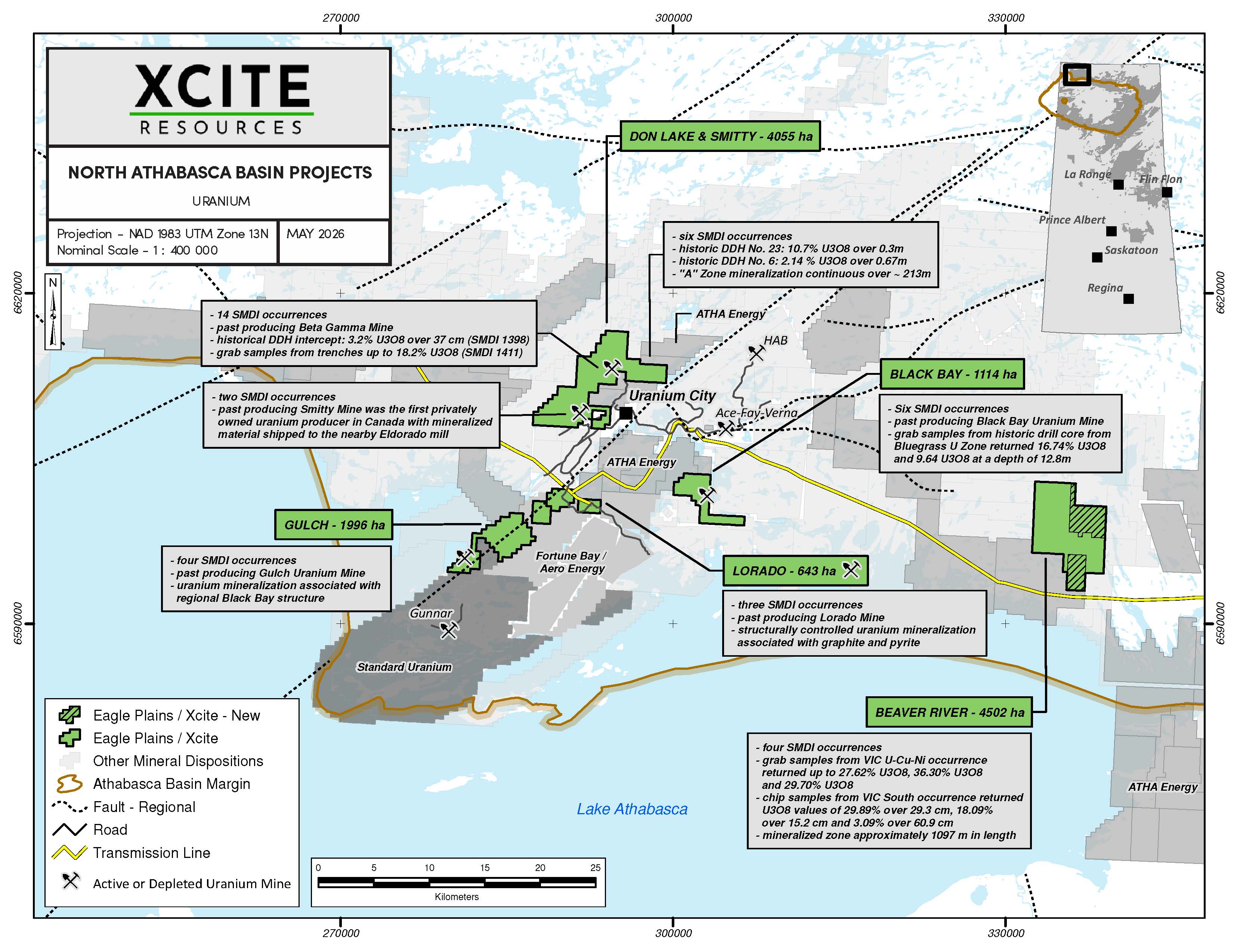
North Athabasca Basin Projects
Click any property marker to view highlights
Portfolio
Property Details
The technical information presented on this page includes historical exploration results, historical production information, and historical resource estimates. Historical estimates should not be treated as current mineral resources or mineral reserves. A qualified person has not completed sufficient work to classify the historical estimates as current mineral resources or mineral reserves, and Xcite is not treating them as current mineral resources or mineral reserves. Historical results are provided for context and may not be representative of mineralization across the properties.
Historical Surface & Drill Sampling
Beaver River
~40 km southeast of Uranium City · 4,502.4 ha · 5 SMDI occurrences
The 4,502.4 ha project overlies 5 SMDI occurrences associated with Beaverlodge-type uranium mineralization. The polymetallic VIC U-Cu-Ni zone (SMDI 1551, 1553, and 1994) occurs along a NW-SE trending fault zone traced for approximately 1 km, with mineralization in fracture-filling quartz veins hosting sulphides, graphite, pitchblende, and uraninite. Initial results from a 2025 VTEM Plus airborne survey flown by Geotech, merged with a 2016 VTEM survey flown for Fission 3.0, show anomalous conductivity and magnetic trends correlating with the VIC and Combined zones. Advanced interpretation and modelling by Condor Consulting is nearing completion. Fieldwork commenced in June 2026, with drill targeting planned for Q3/Q4 2026.
Property Highlights
- Project expanded by 1,469.7 ha through staking to a total of 4,502.4 ha across 5 SMDI occurrences
- Historical channel samples in VIC U-Cu-Ni zone: up to 29.89% U₃O₈ over 0.3m, 18.09% over 0.2m, and 3.09% over 0.6m
- Historical grab samples from the VIC U-Cu-Ni occurrence returned up to 36.30%, 29.70%, and 27.62% U₃O₈
- Historical drill intersections: 0.18% U₃O₈ over 0.3m and 0.06% U₃O₈ over 0.61m with anomalous Cu, Ni, Au, and Ag
- Combined Mining Uranium Showing (SMDI 1557): trench assays of 1.77% U₃O₈ over 0.9m and 0.23% U₃O₈ over 0.5m
- Mineralized trend >1 km in length; northwest portion of VIC zone not yet drill-tested
- Initial 2025 VTEM Plus geophysics shows anomalous conductivity and magnetic trends correlating with the VIC and Combined zones; 2026 fieldwork underway ahead of Q3/Q4 2026 drill targeting
Significant Results
Historical data. Lengths and grades are historical and have not necessarily been verified by Xcite. Additional work is required to verify historical results.
Site Photos
Contiguous Claim Block — High-Grade Drill Zones & Historic Producer
Don Lake – Smitty
~3.5–4 km from Uranium City · 4,055 ha · 14 SMDI occurrences
The Don Lake – Smitty claim block covers 4,055 contiguous hectares located approximately 3.5–4 km from Uranium City, combining two historically significant areas with an additional 2,649 ha of new claims. The Don Lake Area is characterized by significant cross-faulting — notably the Boom Lake and Black Bay faults — with pitchblende mineralization hosted in fractures and veins across three distinct drill zones (A, B, C). Adjacent to the west, the Smitty Area features a 3 km contact along the Smitty fault with Beaverlodge-type uranium in granite; in 1954, the Smitty Mine became Canada's first privately owned uranium producer, operating from 1950 to 1959 with mineralized material processed at the nearby Eldorado mill. The claim block also hosts the past-producing Beta Gamma mine and two historically bulk-sampled mineralized zones. Initial 2025 VTEM Plus geophysics outlined a pronounced conductivity high at Don Lake associated with the Zone A, Zone B, and Hawker Trench occurrences, while the historic Smitty mine sits on an EM conductor high; modelling by Condor Consulting is nearing completion ahead of 2026 fieldwork and Q3/Q4 2026 drill targeting.
Property Highlights
- Contiguous 4,055 ha claim block — 2,649 ha of new claims connecting the Don Lake and Smitty areas
- Don Lake Area, Zone A: 10.7% U₃O₈ over 0.3m (drill) and 8.57% over 0.91m (trench)
- 42 drill holes encountered uranium mineralization with grades ranging from 0.75% to 3% U₃O₈ in the Don Lake Area
- Historical resource estimate: 30,701 lbs of uranium at a grade of 0.71% U₃O₈ (Don Lake Area)
- Smitty Mine: Canada's first privately owned uranium producer (1954); 1.2M lbs total production at 0.20% U₃O₈
- Past-producing Beta Gamma mine; West Uranium Showing historical drilling returned up to 3.2% U₃O₈ over 0.37m; trench grab samples up to 18.2% U₃O₈
- 14 SMDI uranium occurrences across claim block; both properties accessible by road from Uranium City
- Initial 2025 VTEM Plus geophysics: pronounced conductivity high at Don Lake over the Zone A/B and Hawker Trench occurrences; Smitty mine on an EM conductor high
Significant Results
Historical data. Lengths and grades are historical and have not necessarily been verified by Xcite. Additional work is required to verify historical results.
Site Photos
Historic Mine — No Drilling Since 1988
Lorado
~8 km south of Uranium City · 643 ha · 3 SMDI occurrences
The Lorado property encompasses the historical Lorado Uranium Mine, active from 1953 to 1960. Uranium mineralization is structurally controlled, associated with graphite and pyrite within highly altered and metamorphosed argillites. Historical drilling at the Pitchie Zone returned 0.79% U₃O₈ over 1.88m, with other drill results of 0.84% U₃O₈ over 1.0m and 0.23% U₃O₈ over 2.0m. No drilling has been conducted on the property since 1988. Initial 2025 VTEM Plus geophysics shows the Lorado Mine–Pitchie trend along a coincident conductivity and magnetic high.
Property Highlights
- Historical Lorado Mine: ~95,000 tons at 0.19% U₃O₈ (~390,000 lbs uranium, 1953–1960)
- Pitchie Zone drill intersection: 0.79% U₃O₈ over 1.88m
- Ledo Showing: pitchblende in fractures, grab samples up to 0.63% U₃O₈
- Exploration by GLR Resources, JNR Resources & Red Rock Energy (2005–2009)
- No drilling on the property since 1988
- Initial 2025 VTEM Plus geophysics: Lorado Mine–Pitchie trend on a coincident conductivity and magnetic high
Significant Results
Historical data. Lengths and grades are historical and have not necessarily been verified by Xcite. Additional work is required to verify historical results.
Site Photos
High-Grade Surface & Drill Results
Black Bay
~10.9 km SE of Uranium City · 1,114 ha · 6 SMDI occurrences
The Black Bay property hosts Beaverlodge-style basement-hosted uranium mineralization, characterized by pitchblende occurring near lithological contacts and faults, often associated with hematite and graphite. The Bluegrass U Zone — located 600 metres northwest of the historic Black Bay Mine — returned high uranium grades of 16.74% U₃O₈ and 9.64% U₃O₈ from grab samples of drill core at a depth of 12.8 metres. Initial 2025 VTEM Plus geophysics shows uranium mineralization occurring along the flanks of a pronounced magnetic high.
Property Highlights
- Bluegrass U Zone (600m NW of Black Bay Mine): grab samples from drill core returned 16.74% U₃O₈ and 9.64% U₃O₈ at a depth of 12.8m
- Zone C: 0.91% U₃O₈ (6.1 × 4.6m); Zone B: 0.72% (22.9 × 1.5m); Zone A: 0.47% (13.7 × 0.9m)
- Zone B drilling: 3.78% U₃O₈ / 0.3m and 3.62% / 0.3m
- Historic Black Bay Uranium Mine: ~1,375 tons at 0.17% U₃O₈ (1950s), processed at the nearby Lorado mill
- Bearcat Au Showing: No. 1 Zone grab 0.471% U₃O₈; No. 2 Zone grabs up to 0.520% U₃O₈ and drill assays 0.2147% U₃O₈ / 0.5m; No. 3 Zone chip samples up to 2.285% U₃O₈ over 0.10–0.20m widths
- 6 SMDI occurrences — multiple mineralized zones across the property
- Initial 2025 VTEM Plus geophysics: uranium mineralization along the flanks of a pronounced magnetic high
Significant Results
Historical data. Lengths and grades are historical and have not necessarily been verified by Xcite. Additional work is required to verify historical results.
Site Photos
Large Historical Resource
Gulch
~20 km SW of Uranium City · 1,996 ha · 4 SMDI occurrences
The Gulch property hosts uranium associated with the regional Black Bay fault structure, indicating potential for both basement-hosted and unconformity-related deposits. The historic Gulch Mine developed 11 mineralized shoots through underground operations and diamond drilling between the 152m and 244m development levels. A 2007 VTEM survey conducted by JNR Resources outlined a large electromagnetic conductor on the property that has not been drill-tested. Initial 2025 VTEM Plus geophysics defines the regional Black Bay Fault along a break between anomalous high conductivity to the east and low conductivity to the west.
Property Highlights
- 11 mineralized shoots: 18.3–48.8m length and 1.2–4.3m width (active 1953–1957)
- Development levels at 152m and 244m depth
- Historic resource: ~598,000 tonnes @ 0.126% U₃O₈ (~1.65M lbs uranium), open at both ends to a depth of 122m
- Martin Group Unconformity: pitchblende in faults, 1+ km radiometric anomaly
- Duvex Oils & Mines radioactive zones: grab samples up to 2.23% U₃O₈
- Lucy Occurrence: uranium values up to 0.37% U₃O₈ over 3m (1954)
- Large untested VTEM EM conductor identified in 2007 JNR Resources survey; 2025 VTEM Plus geophysics defines the Black Bay Fault along an east–west conductivity break
Significant Results
Historical data. Lengths and grades are historical and have not necessarily been verified by Xcite. Additional work is required to verify historical results.
Site Photos
Strategy
Strategic exploration roadmap
Scroll horizontally to explore each stage
Historic work compilation (completed)
Digitize and consolidate historical drill logs, geophysics, and sampling data.
Radiometric / EM survey (completed)
Airborne radiometric and EM programs completed across priority zones.
Lidar survey
Acquire high-resolution terrain data to refine structures and lineaments.
Groundwork mapping for graphite conductors
Field mapping focused on graphite-rich structural corridors.
Sampling and trenching of structures
Surface sampling and trenching to verify structural mineralization trends.
Target generation
Integrate all datasets to rank and define drill-ready targets.
Drilling targets
Test highest-priority targets with initial drill campaigns.